
Clouds are a significant part of our everyday weather, they can give us an idea of what kind of weather we can expect in the future. Clouds come in many different shapes and sizes and knowing the difference between them can tell you whether we will have a calm day or we have storms on the horizon and you might want to get inside. Before we get into the different types of clouds, let’s take a trip back to elementary school where we learned how clouds form through…the water cycle.
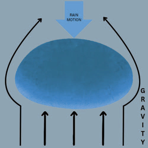
As the sun’s rays beat down on Earth and heats up the surface, water from many different areas like lakes, rivers or even the ground warm up and eventually escape into the air through a process called evaporation. As the water rises, the surrounding air temperature cools with increased height.
The point at which the air temperature and the water temperature (or dew point) equal, the water will start to form the base of a cloud. Meteorologists refer to the base of the cloud as the Lifting Condensation Level (LCL) and that’s the part of the water cycle where…yep, you guessed it…condensation begins.
Imagine millions of tiny, invisible air parcels forming these clouds but sometimes they aren’t heavy enough to defeat gravity and just keep the water contained inside. When the water inside wins the head to head battle with gravity, the next step of the water cycle occurs… precipitation.
Fun Fact: Most people assume that raindrops look like tears but they actually start as a sphere. As they grow in size, the force of gravity acts against them, turning them into a shape resembling the top half of a hamburger bun just without the sesame seeds.
The precipitation that falls out of the cloud is collected by the areas I mentioned earlier (lakes, rivers, ground, etc.) and the process repeats in an endless cycle. Now that we’ve learned how clouds form, let’s explore the many different types of clouds and that’ll help you determine what kind of weather we are about to experience.
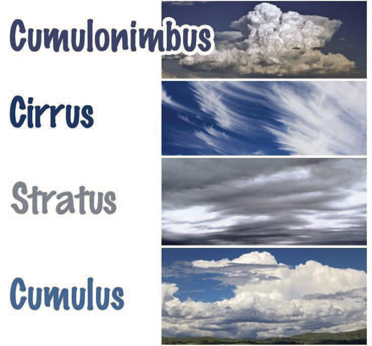
Clouds can be classified into 4 different types, cirro-form, strato-form, cumulo-form & nimbo-form. The Latin word “cirro” means curl of hair.
Cirro-form clouds are composed of ice crystals so they’re at an elevation (usually above 20,000 ft) where the temperature is below freezing or 32 degrees Fahrenheit. These clouds are wispy and, like the Latin definition, hair-like indicating that an area of low pressure is incoming.
Strato-form is derived from the Latin word meaning “layer”. They are broad, widespread and look like a blanket covering the atmosphere. Stratus clouds usually occur on the north side of a warm front and ongoing rain/snow can be expected.
Next up is cumulo-form, the Latin word “cumulus” means heap which perfectly describes these clouds that look like piles of cotton balls in the sky. Cumulus clouds can appear during good and bad weather but adding the fourth and final category to them are the types of clouds that we’re far too familiar with in Oklahoma.
Let’s be honest, the first three categories are a little boring. Last but not least, nimbo- form can be added to any of the previous categories to indicate precipitation inside of the cloud. The Latin word “nimbus” stands for rain and other precipitation types can be seen coming out of these clouds, making them generally the thickest cloud type.
The thickest of them all are the infamous, cumulonimbus clouds and usually those are a sign to Oklahomans that we need to prepare for the worst possible outcome. Imagine a hot, summer-like day in Oklahoma. The wind from the south feels like a hair dryer is put on full blast in front of your face.
You look around the sky and these puffy, white clouds (recall cumulo-form) fill the sky but they aren’t that big or don’t have a lot of height to them. You look down and within a matter of half an hour, you notice the clouds are starting to build with height and resemble a stereotypical shape that we normally associate with severe thunderstorms in our neck of the woods.
The reason being is that the air above us can be much more moist and unstable than that at the surface. The lower portion still resembles that of cotton balls but as you look higher and higher, the upper portion is usually a lot smoother and flatter, giving it that anvil shape that we’re accustomed to.
Inside of the cumulonimbus cloud, the updraft of warm rising air is lifting these parcels of air higher and higher until the surrounding air reaches the same temperature or even warmer, meteorologists refer to that as the Equilibrium Level (EL).
Sometimes the updraft is so fast that the air parcels carry enough momentum to actually rise past the flat top of the cloud before descending back down. This adds a dome-like top on the cumulonimbus cloud and represents a very good possibility of severe weather.
The upward motion of warm air interacts with winds of different speeds and directions inside of the cloud causing the updraft to start rotating. Normally, the stronger the rotation equals a more robust severe thunderstorm is occurring.
The rotating winds cause the water inside of the cloud to travel all around colliding with drops of different sizes and once they are too heavy for the updraft to continue supporting them, they fall through the cloud and to the ground.
The same process can be applied for hailstones but this occurs at an elevation where the temperature is below freezing. Some hail stones are smooth and round like a ball and some of them look like something straight out of a horror movie with spikes and jagged edges.
Fun Fact: The largest hailstone in the US fell to the ground in South Dakota in 2010. It had a diameter between 7.5 and 9 inches, that’s the same size as a small pizza but I wouldn’t recommend covering it in cheese and toppings and eating it.
Hailstones greater than softball size (4 inch diameter) can travel well over 100mph. Last but certainly not least, another weather phenomenon that can have speeds over 100mph…a tornado.
Essentially, a tornado can be described as a low pressure system but on a much smaller scale than what we normally associate that term with. A mesocyclone, or a vortex of wind in the lower atmosphere below the cloud base, takes in cool, moist air from the storm’s downdraft.
The mixing between that cool, moist air and the rising warm air causes a wall cloud to extend from the cloud base. As the updraft intensifies and the downdraft is focused on a smaller area on the surface, a funnel descends from the wall cloud.
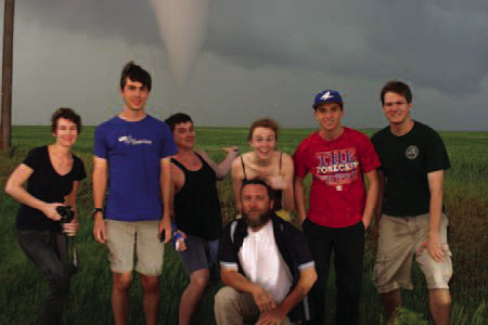
Now you can start to see damage on the ground in the form of a debris-spinning column but the point at which the funnel feeds into that is when you can officially call in to your local authorities and say that a tornado is on the ground (my classmates and I, red shirt, back in 2013 chasing a tornado in Larned, Kansas).
So there you have it, a complete guide on the 4 different cloud types, how they form and what they can mean for the weather pattern in a matter of minutes or days. Western Oklahoma paints an endless picture built for curious minds with open skies, rolling plains and wide horizons.
Whether you’re watching thunderheads build like skyscrapers over Sayre or tracing cirrus streaks over a grain elevator in Erick, the sky here talks. All you have to do is look up and listen.